Was the thought of identifying latitude and longitude on a map in geography class one of your high-key stressors? Well, you’re not the only anxiety-ridden test taker out there!
The concept of measuring Earth by coordinates isn’t an overwhelmingly hard concept to grasp, but identifying the difference between these two words can be a little tough.
Since they are both units of measurement that help identify coordinates and literally intersect with each other, it is easy to see why they are so confusing. But the main reason they get people in such a tizzy might be that their definitions don’t necessarily line up with what we expect for each word.
What is longitude?
Longitude is defined as the “geographical angular distance east or west on the earth’s surface” or, for the directionally-challenged, left to right. To clarify: the lines of longitude run from pole to pole but measure left to right.
This word can be confusing because the word long (which appears at the beginning of longitude) is an adjective that often describes height, something we typically think of as measuring from top to bottom (or in geographical terms, north to south). A dress can be too long, for example, or someone can have long arms.
And looking at the etymological roots, it gets even more bewildering. Dating to the 1300s, the roots of this word literally mean both “length” or “height.” (It is derived from the Latin longitudo ” meaning “length, long duration.”)
What is latitude?
Essentially, latitude is defined as the exact opposite: “the angular distance north or south from the equator of a point on the earth’s surface.” Lines of latitude run horizontally to measure north to south.
Etymologically speaking, its roots are slightly less perplexing than longitude‘s. Also dating back to the late 1300s, latitude means “breadth” but goes even further back to the Old French latitude, and the Latin latitudo, meaning “breadth, width, extent, and size.” So when you think of latitude, you can think of a distance expanding far and wide, in this case from north to south covering an area from top to bottom.
Latitude also has a more colloquial use as well. In this respect it means “freedom from narrow restrictions,” so it could be used as follows: She gave her daughter a lot of latitude when it came to expressing herself creatively.
How do you use each word correctly?
First it is important to get the units of measurement straight. Now that you know that longitude is tied to length, a small memory trick can be that longitude stands for “longways” indicating a measurement that stretches across the globe.
Latitude is rooted in the word extend, so think of extending something or reaching from top to bottom (aka north to south).
Teachers and schoolchildren use a series of rhymes to remember the difference. For latitude, kids often talk about the concept of a ladder. The trick is to remember latitude sounds like ladder, and that refers to the rungs of the ladder:
I’m climbing the Ladder of Latitudes, Latitudes, Latitudes.
I’m climbing the Ladder of Latitudes, all around the world.
Longitude has its own song too, which focuses on the fact that long, north and south all use the letter O:
It’s a long, long way from pole to pole, pole to pole, pole to pole.
It’s a long, long way from pole to pole, so we call those longitudes.
More helpful information
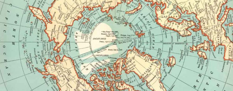
To use latitude and longitude as a measurement, you have to understand that latitude is measured in degrees north (+) and degrees south (-). The equator, or the middle point, measures at zero. The northernmost point reads at 90 degrees North (+) and the southernmost point reads at 90 degrees South (-).
Longitude is measured by how far a point is east (+) or west (-) of the prime meridian (which is set as Greenwich, England). The prime meridian is set at zero degrees longitude. When moving east or west, the longitude measures up to 180 degrees East or West (+ or -) of the prime meridian.
Degrees are used as the units to measure longitude and latitude, and they are divided to the decimal point. That’s referred to as decimal degrees.
Assume that the top of every map indicates north. The numbers on the right and left sides of a map refer to the latitude. The numbers on the top and bottom of the map are the longitude, so as you follow along the grid to determine where a location is, you can identify them positively or negatively by their latitude or longitude depending on direction.